WHAT WE DELIVER
We detect, geolocate and classify ships at sea, including “dark ships” that turn off or manipulate their declarative shipborne systems (AIS or VMS).
We thus strengthen maritime domain awareness, helping public & private stakeholders uncover suspicious activities and improve security, compliance and enforcement. This is made possible by Unseenlabs’ RF intelligence, powered by its one-of-a-kind monosatellite technology that enables the detection of more emitters than any other solution.

You select, we deliver
Identify your needs and gain actionable insights tailored to your objectives
Customize your monitoring needs and receive precise, reliable, lightweight, and actionable RF intelligence.
STEP 1
You select
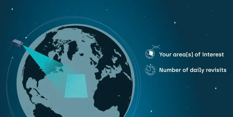
step 2
we deliver
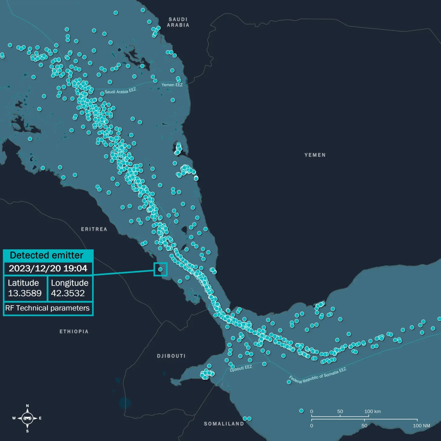
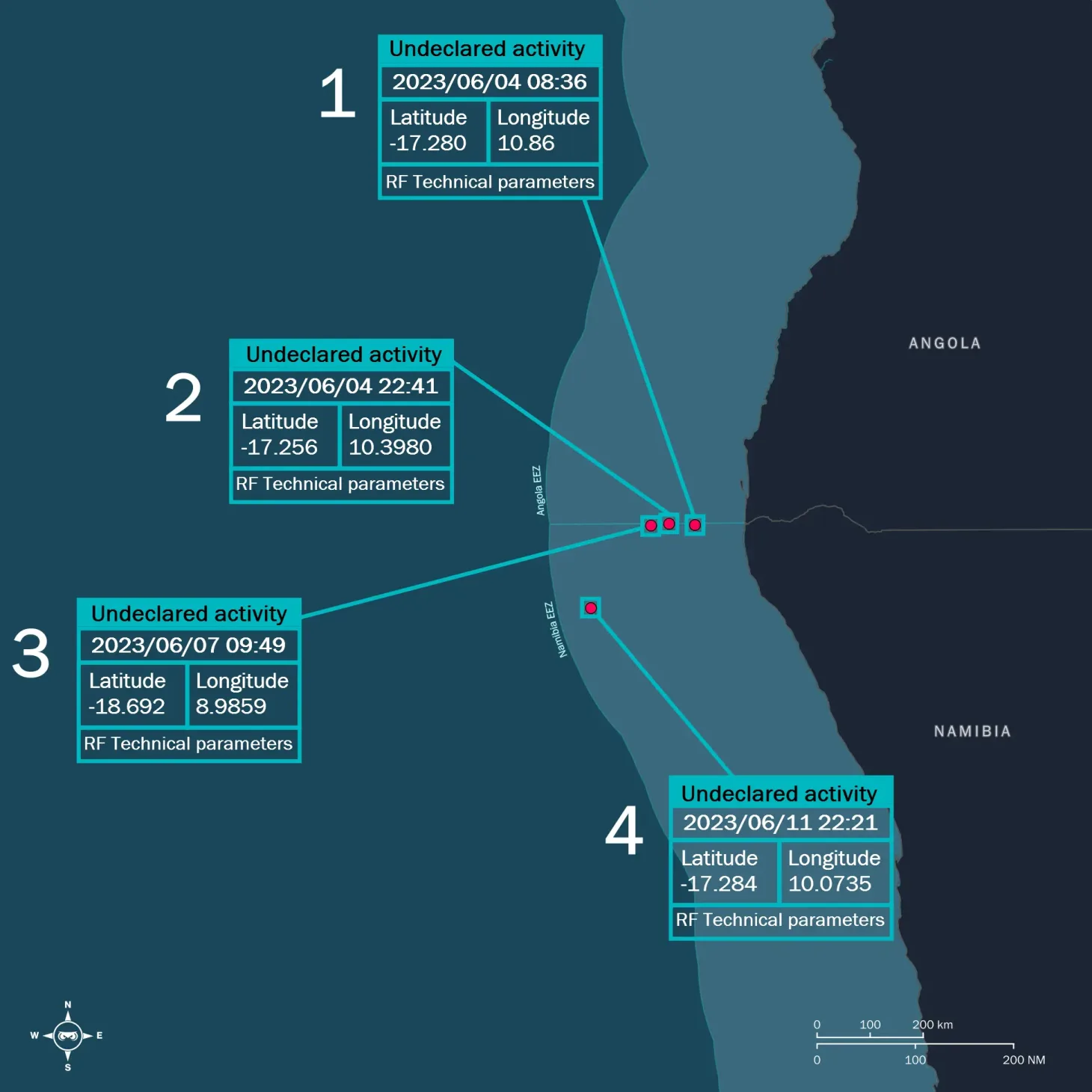
For each RF data collection, we deliver a comprehensive list of all detected emitters in standard format files, including:
- Geolocation coordinates
- Accurate timestamps
- RF technical parameters
- Dark vessels detection & monitoring
If you need more, get customized solutions for deeper analysis needs:
- Intelligence reports
- Technical training
- Data Visualisation portal
- Urgent requests


What is space-based RF detection?
Space-based RF detection relies on satellites intercepting electromagnetic signals emitted by electronic equipment on Earth's surface. This technology seamlessly integrates with other systems to enhance situational analysis.
Radio frequencies encompass a broad spectrum of radio waves, ranging from 3 kHz to 300 GHz, categorized into distinct frequency bands. Each band has unique properties and applications, including bandwidth, range (short, medium, or long), and sensitivity to obstacles or atmospheric conditions.
At sea, ships are equipped with various communication and navigation systems that continuously or intermittently emit signals, propagating across different ranges.
What does ISR stand for?
ISR (Intelligence, Surveillance, and Reconnaissance) refers to the equipment and systems deployed across land, sea, air, and space to collect critical information. It also encompasses the data processing and human expertise required to analyze situations effectively and support informed decision-making in defense and civilian operations.
What is Maritime Domain Awareness?
Oceans and seas pose a wide range of environmental, security, safety, sovereignty, and economic challenges for humanity.
Maritime Domain Awareness (MDA) involves all activities aimed at enhancing visibility and understanding of maritime operations.
What is AIS?
AIS (Automatic Identification System) is a VHF transceiver system originally designed to prevent ship collisions.
Ships can detect AIS signals from each other at distances of up to 20 nautical miles, while shore-based systems positioned on high ground can extend that range to approximately 60 nautical miles. Satellite AIS (S-AIS) further expands coverage, enabling data transmission for commercial services. AIS signals provide critical information, including a vessel’s course, speed, name, call sign, registration number, and classification.
The International Maritime Organization (IMO) mandates AIS for certain vessels. Specifically, it is required for:
- All ships of 300 GT (Gross Tonnage) and above navigating international waters
- All ships of 500 GT and above sailing in territorial waters
- Fishing vessels over 15 meters operating in EU waters
While AIS is one of the most widely used maritime tracking systems, it is only mandatory for 3 to 5% of all vessels at sea, leaving a significant portion of maritime activity unmonitored.
Space-based RF detection vs AIS
Space-based RF detection enhances Maritime Domain Awareness by intercepting signals from a wide range of vessels at sea, including those without AIS—commonly known as “dark ships or vessels” (ships that have turned off or spoofed their AIS signals).
Similar to AIS, RF data is commercially accessible, lightweight, and easy to interpret. It can also be integrated with other intelligence sources to provide a more comprehensive and accurate understanding of maritime activity.